Ottawa National Forest
near Bessemer MI
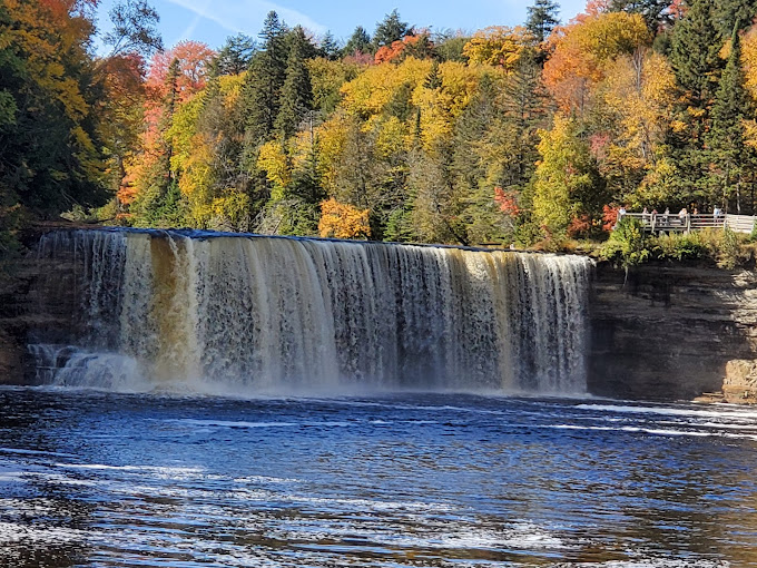
Rainbow Falls is the last of the five major waterfalls on the Black River just before it empties into Lake Superior. Bloated with the accumulation of the many springs and creeks along its northward course, the Black River, almost 60 feet wide here, is really bursting with hydraulic energy. T entire river The falling water (40 feet) creates a mist, and sometimes with the right angle of sunlight, produces a rainbow effect, which gives the falls its name.
A 1/2 mile hiking trail will take you from a paved parking lot to a stairway dropping down to an observation platform overlooking the scenic Black River and Rainbow Falls.
Rainbow Falls can also be viewed from the east side of the river. This side will provide the photographer with a better angle of the falls. From the east side you can view the cavernous hole which diverts the plunge at the base of the waterfall. Trail access to the east side begins over the suspended foot bridge at Black Harbor Picnic Area. This trail is 3/4 mile long via the North Country Scenic Trail.
If you visit this area in September, you can watch the chinook and salmon fight their way upstream to their ‘nesting’ areas.How to get to Rainbow Falls:
- From US-2 in Bessemer, head north on N. Moore St to St Johns Rd (about 0.7 miles).
- Turn left and go to Black River Rd (about 0.5 miles).
- Turn right on Black River Rd which becomes the Black River Harbor Pkwy (County Rd 513).
- Follow this road, through North Bessemer and Auvinen Corner, past Cooper Peak, Chippewa Falls and Algonquin Falls, to the Rainbow Falls Parking area (on your right across from the Campground) – about 14 miles from Bessemer and about 1.3 miles past the Potawatomi Falls parking lot (also on your right).
- Turn right, park in the paved parking area and follow the trail to Rainbow Falls.
- The trail is an 0.25 mile trail leading from the parking lot, down a series of steep steps, to the falls overlook. Sandstone Falls, Gorge Falls, Potawatomi Falls and Great Conglomerate Falls are all within a few miles of each other along the North Country Scenic trail here. (Gorge Falls and Potawatomi Falls can also be hiked to (upstream 1/2 mile) via this North Country Scenic Trail.).
Sandstone Falls, Gorge Falls, Potawatomi Falls and Great Conglomerate Falls are all within a few miles of each other along the North Country Scenic trail here. A little further upstream (to the south) are Algonquin Falls and Chippewa Falls accessible from a trailhead at the parking area between the two and just north of the Cooper Peak access road. See the excellent map of this area at the Michigan Interactive web site: www.fishweb.com/maps/gogebic/waterfalls/blackrv_parkway/map.html
Gorge Falls and Potawatomi Falls can be reached from Rainbow Falls by going south on the North Country Scenic trail (upstream about 2 miles).
Great Conglomerate Falls can also be reached by going south (upstream about 2.5 miles).Photos of Rainbow Falls:
- PictureMichigan.com Picture Gallery
- Photo of Rainbow Falls from the East Bank of Black River (top photo)(from Michigan Interactive web site)
For more information:
- Ottawa National Forest
E6248 US 2
Ironwood, MI 49938
906-932-1330
[email protected]web site: http://www.fs.fed.us/r9/ottawa/- Ontonagon County Chamber of Commerce
Information Center
Highway MI-64 and River Road
Ontonagon
906-884-4735
[email protected]See Also:
Hotel and Motel accommodations, are available in the following communities: Baraga
Calumet
Cedarville
Escanaba
Hancock
Houghton
Iron River
Ironwood
IshpemingMackinaw City
Manistique
Marquette
Menominee
Munising
Newberry
Norway
Paradise
Sault Ste Marie
Wetmore